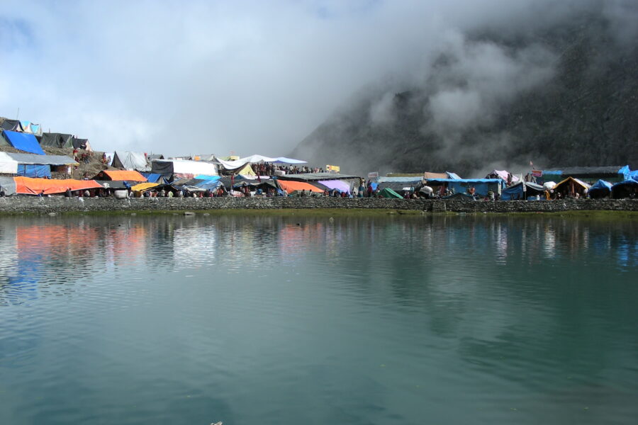
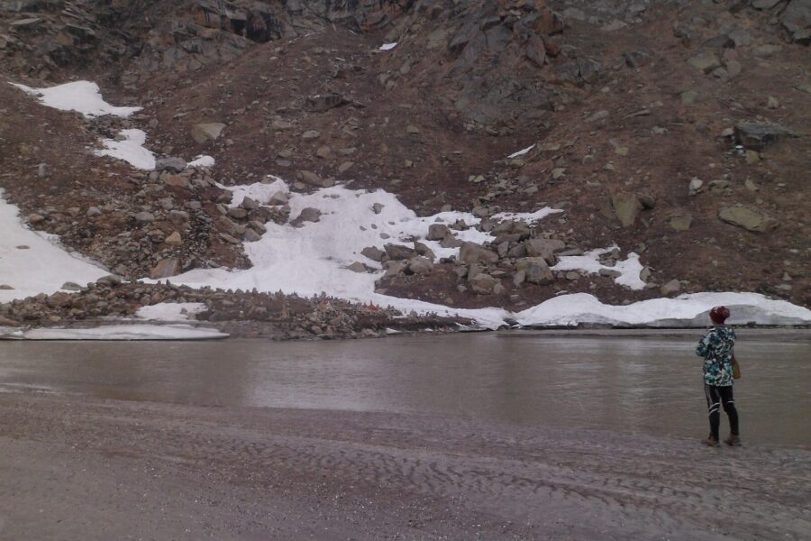
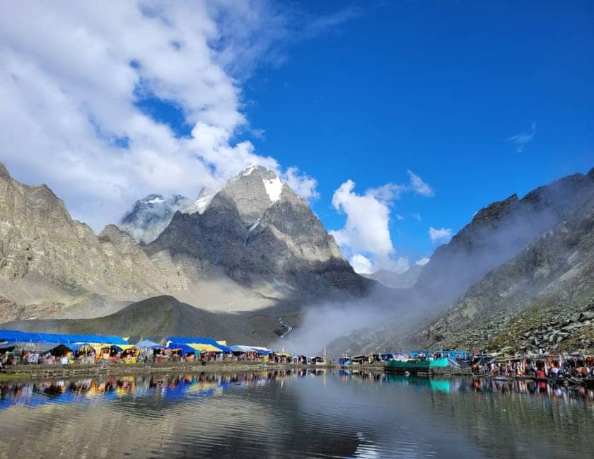
Manimahesh

Know the trail before you step on it - difficulty, permits, weather, guide need and route clarity in one place.

Trek safety, weather & access status

Generally safe to travel Open to trek Nov–Jun

Advisory

No active alerts. Carry layers, keep emergency contacts handy and check local conditions before you set out.

Live weather

4°C Partly cloudy
  • Feels 3°C
  • 2 km/h wind
  • 75% humidity

Mountain weather changes quickly. Treat this as a planning signal, not a final safety clearance - confirm locally before you set out.

Max altitude 4,080 m
Distance 13 km one way
Duration 2 days
Best time August to September (yatra)
Fitness Moderate to high - a steady climb to a high lake; ponies and helicopter available
Start point Hadsar
End point Hadsar
No permit needed

DIY Trek Readiness: can you go self-planned?

Beginners Some experience helps
Guide Optional / self-guided
Permit Not needed
Fitness Moderate to high - a steady climb to a high lake; ponies and helicopter available
Trail clarity Clear
Network on trail Patchy
Max altitude 4,080 m
Best season Nov–Jun
Languages Hindi, Gaddi

Readiness verdict

  • Best forExperienced, fit trekkers comfortable at altitude
  • Not ideal forFirst-time trekkers going without any support
  • Go DIY only ifYou can manage long walking days, basic navigation and changing mountain weather.
Guide: Optional Permit: Not needed Network: Patchy
Plan it yourself

The DIY deep-dive

DIY route options

The classic route Start from Hadsar and follow the standard 2-day line - the most reliable, well-trodden way to do it.
Time it by season Plan around August to September (yatra) for the best weather, views and open access.

What most travellers miss

  • Download offline maps and share your plan first - the mobile network here is patchy to none.
  • Time it for August to September (yatra). Outside that window, snow, weather or road closures can cut access.
  • Use the acclimatisation day in full - fast itineraries are what catch people out at altitude here.

Where to base yourself

Dhancho Trailhead base - last shops, network and gear before you set off.

DIY is the main way - this is the upgrade

Need expert help planning this trek?

Prefer not to manage permits, guide coordination, stays and route pacing yourself? We can help you turn this trek into a private, supported experience for your dates, group size and comfort level.

  • Permit and guide coordination
  • Private group support
  • Route pacing and halt planning
  • Stay, meals and local logistics
Enquire for pricing Enquire on WhatsApp

About this trek

Manimahesh is a glacial lake at 4,080m at the foot of Manimahesh Kailash, one of the five Kailashes, above Bharmour in Chamba. The yatra climbs from Hadsar for a holy dip and darshan, peaking around Janmashtami (Aug-Sep).

Essential packing list

  • Trekking shoes
  • Warm layers
  • Rain shell
  • Headlamp
  • Water bottle
  • Trekking shoes with grip
  • Warm base layers and fleece
  • Down jacket
  • Rain shell / poncho
  • Headlamp with extra batteries
  • Water bottle or hydration bladder
  • Sunglasses, cap and sunscreen
  • Personal medicines
  • Power bank
  • Offline maps
  • Cash and ID copies
  • Permit documents

Map

Nearby route landmarks & places to know

Tap β€œGet directions” to open any spot straight in Google Maps.

Manimahesh Lake

0 km from Hadsar, Himachal Pradesh centre

Manimahesh Lake is considered a sacred lake in the Hindu religion. This lake is situated on the Manimahesh Kailash mountain, one of the Panch Kailash mountains mentioned in the Sanatan religion.Manimahesh is a high al…

Manimahesh Kailash Peak

3.1 km from Hadsar, Himachal Pradesh centre

Manimahesh Kailash, also known as Chamba Kailash, is a mountain in the Himalayas, and one of the Panch Kailash mountains mentioned in Sanātana Dharma. At a height of 5,653 metres (18,547Β ft), it stands high over the M…

Stay & food planning around the trailhead

Base and stock up at the trailhead before you start; on the trail expect basic halts and simple meals - tea stops and packed snacks, with no cafe-style reliability once you set off.

Stay

Manimahesh Temple Sarai

Manimahesh Temple Sarai, Manimahesh Lake Dhanchho Trail, -, Himachal Pradesh, India

Open in Maps

Stay

Manimahesh Temple Sarai

Manimahesh Temple Sarai, ManiMahesh Dal to Kamal Kund Trail, -, Himachal Pradesh, India

Open in Maps

Stay

Forest Rest House, Trehta, Holi

Forest Rest House, Trehta, Holi, Forest Rest House Approach Road, Holi - 176309, Himachal Pradesh, India

Open in Maps

Stay

Karthik Hotel

Karthik Hotel, Forest Rest House Approach Road, Holi - 176309, Himachal Pradesh, India

Open in Maps

Stay

Japotra

Japotra, Chamba Bharmour Road, Dinka - 176315, Himachal Pradesh, India

Open in Maps

Comments are closed.

More treks nearby

View all

Travel guides related to Manimahesh

View all