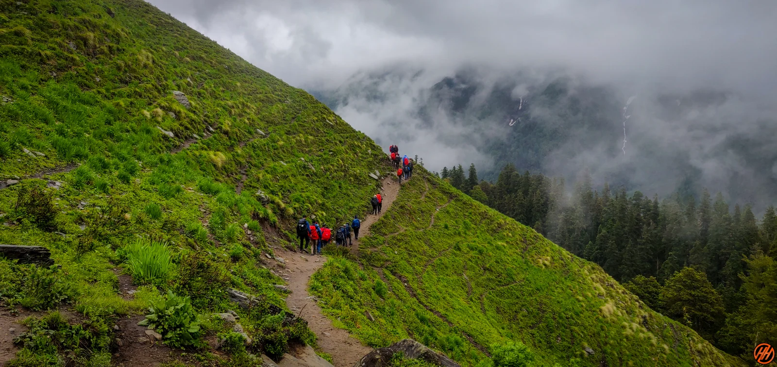
Buran Ghati Trek

Know the trail before you step on it - difficulty, permits, weather, guide need and route clarity in one place.

Trek safety, weather & access status

Generally safe to travel Open to trek May–Jun, Sep–Oct

Advisory

No active alerts. Carry layers, keep emergency contacts handy and check local conditions before you set out.

Live weather

12°C Overcast
  • Feels 10°C
  • 3 km/h wind
  • 70% humidity

Mountain weather changes quickly. Treat this as a planning signal, not a final safety clearance - confirm locally before you set out.

Max altitude 4,575 m
Distance 38 km
Duration 7 days
Best time May to June, September to October
Fitness High - a pass crossing with a rope descent
Start point Janglik
End point Barua
No permit needed

DIY Trek Readiness: can you go self-planned?

Beginners Some experience helps
Guide Recommended
Permit Not needed
Fitness High - a pass crossing with a rope descent
Trail clarity Faint
Network on trail None
Max altitude 4,575 m
Best season May–Jun, Sep–Oct
Languages Hindi, Pahari

Readiness verdict

  • Best forExperienced, fit trekkers comfortable at altitude
  • Not ideal forFirst-time trekkers going without any support
  • Go DIY only ifYou can manage long walking days, low or no network, basic navigation and changing mountain weather.
Guide: Recommended Permit: Not needed Network: None on trail
Plan it yourself

The DIY deep-dive

DIY route options

The classic route Start from Janglik and follow the standard 7-day line - the most reliable, well-trodden way to do it.
Self-guided or with a guide Do it solo with the offline Gaia GPS trail file, or hire a local guide at Janglik for the navigation and logistics.

What most travellers miss

  • Download offline maps and share your plan first - the mobile network here is patchy to none.
  • Do not rush past Dayara Thach - most people treat it as a quick stop, but it is worth a slower evening.
  • Time it for May to June, September to October. Outside that window, snow, weather or road closures can cut access.
  • Use the acclimatisation day in full - fast itineraries are what catch people out at altitude here.

Where to base yourself

Janglik Trailhead base - last shops, network and gear before you set off.
Dayara Thach A key stop on the route - where the trek halts for the night.
Litham A key stop on the route - where the trek halts for the night.

DIY is the main way - this is the upgrade

Need expert help planning this trek?

Prefer not to manage permits, guide coordination, stays and route pacing yourself? We can help you turn this trek into a private, supported experience for your dates, group size and comfort level.

  • Permit and guide coordination
  • Private group support
  • Route pacing and halt planning
  • Stay, meals and local logistics
Enquire for pricing Enquire on WhatsApp

About this trek

Buran Ghati links the apple villages of the Pabbar valley to the meadows of Barua over a 4,575m snow pass. The highlight is the descent – a near-vertical snow wall you come down on a rope. Forests, the Dayara meadow and the Chandranahan lakes make it one of Himachal’s finest.

Essential packing list

  • Trekking shoes
  • Warm layers
  • Rain shell
  • Headlamp
  • Water bottle
  • Trekking shoes with grip
  • Warm base layers and fleece
  • Down jacket
  • Rain shell / poncho
  • Headlamp with extra batteries
  • Water bottle or hydration bladder
  • Sunglasses, cap and sunscreen
  • Personal medicines
  • Power bank
  • Offline maps
  • Cash and ID copies
  • Permit documents

Map

Nearby route landmarks & places to know

Tap β€œGet directions” to open any spot straight in Google Maps.

Chanderkhani

6.9 km from Janglik, Himachal Pradesh centre

Chanderkhani Pass is a pass located in the Kullu District of India at a height of 3,660 metres. It forms a way (pass) between the villages of Rumsu and Pulag to the well known village of Malana, which indirectly forms…

Parvati River (Himachal Pradesh)

8.4 km from Janglik, Himachal Pradesh centre

Parvati River is a river in the Parvati Valley in Himachal Pradesh, northern India that flows into the Beas River at Bhuntar, some 10Β km south of Kullu. It rises from the Man Talai Glacier below the Pin Parbati Pass a…

Stay & food planning around the trailhead

Base and stock up at the trailhead before you start; on the trail expect basic halts and simple meals - tea stops and packed snacks, with no cafe-style reliability once you set off.

Stay

Shiela's Homestay

Shiela's Homestay, Bhuntar Manikaran Highway, Dunkharamul - 175105, Himachal Pradesh, India

Open in Maps

Stay

Ghan Shyam’s place

Ghan Shyam’s place - hotel restaurant, Sar Pass Trail, Garahan - 175105, Himachal Pradesh, India

Open in Maps

Stay

Shanti palace home stay

Fool moon best view, Sar Pass Trail, Garahan - 175105, Himachal Pradesh, India

Open in Maps

Stay

Mannat home stay

Mannat home stay, Bhuntar Manikaran Highway, Dunkharamul - 175105, Himachal Pradesh, India

Open in Maps

Stay

village guest house

village guest house, Bhuntar Manikaran Highway, Dunkharamul - 175105, Himachal Pradesh, India

Open in Maps

Stay

Metora

Metora, Bhuntar Manikaran Highway, Dunkharamul - 175105, Himachal Pradesh, India

Open in Maps

Stay

Hotel Malabar

Hotel Malabar, Bhuntar Manikaran Highway, Shat - 175101, Himachal Pradesh, India

Open in Maps

Comments are closed.

More treks nearby

View all

Travel guides related to Buran Ghati Trek

View all